The Alcan Highway, also known as the Alaska Highway, has long had a reputation among roads. It is famous for being one of the most remote and rugged major highways in North America.
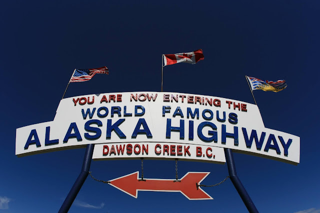
The Alaska Highway begins in Dawson Creek, British Columbia. It runs 1387 miles (2232 km) through the British Columbian Canadian Rockies. It goes through Whitehorse, and Yukon Territories. Ending in Delta Junction, Alaska, outside of Fairbanks.
In early 1942, America was mobilizing after Japan had recently attacked Pearl Harbor. Japans was active off of the US West Coast. Threats to the Aleutian Islands were obvious. The was a need for an inland route to Alaska from the lower 48. A highway could transport supplies, men and equipment to Alaska.
In the 1920's a proposal were made for a highway. It would connect Central British Columbia with the Yukon Territory and Alaska. Cost and lack of serviced communities had prevented its construction. The plan was introduced several times without success. The war caused the highway to be approved.
 |
| Alaska Highway Proposed Route 1938 |
The United States was anxious to address the supply chain issues. They offered to build pay and provide labor to build the highway. America would use it during the war. After the war, Canada was then to take over. The segment of the highway that passed through Canada was to be Canadian. Operations and maintenance expenses belonging to Canada. The Canadians agreed. Construction began in March 9, 1942.
The route connected airports found along the Northwest Staging Route. This was a network of airstrips built at the same time as the highway. The air bases were to transport planes to the Soviet Union, our ally at the time. The Staging Route never was used to supply the Soviets. It did provide stations for equipment to be flown in. This was helpful when building the highway.
Conditions were extreme. It was difficult for road building. There was Sub Arctic weather and heavy forests. Water was everywhere. Many lakes and rivers needed a bypass or forging. Large areas of permafrost created unique challenges. There was plenty of wildlife, especially bears.
 |
| Building The Highway |
Building was in a dangerous environment. The job was almost always menial labor using shovels and axes. There is an obvious example of Army racism tied to the highway. The Army sent three of its new formed "Negro Regiments" to weather the extreme conditions. The heavy lifting of the remote and challenging project done by them.
When construction began that winter in 1942, the ground was frozen hard. The troops made fast progress. They worked with hand tools and light bulldozers. Slowly the troops scratched a path through the wilderness. At river crossings, pontoon bridges served until more permanent structures were built.
The troops had no experience building on permafrost. Some of the early road failed. As warmer weather hit the road exposed now thawing frozen areas. The sunlight was actually melting the ground the highway was built on. The roadbed in places sank into a swampy murk.
Solving this problem, a technique was adopted. New felled trees were placed down across the roadbed. They made a sort of corrugated cover to the permafrost. Several layers would be added. The logs to sank into the swampy earth. More layers would settle into a surface solid enough to overlay with gravel.
The workers had no pipeline to supply fuel for the heavy equipment. Fuel was airlifted to the site in 55 gallon oil cans. Many empty cans littered the construction sites. The road was jokingly called the Oilcan Highway by some.
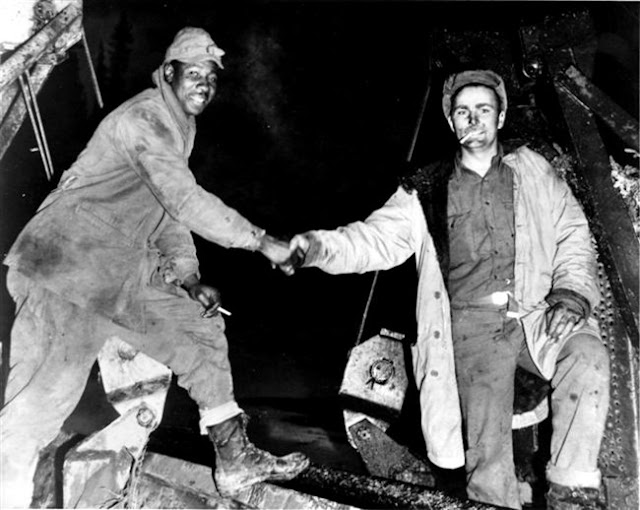
An amazing display of urgency, the highway was completed in only 9 months. It was almost 1400 miles of rough, yet passable roadway. Teams from both working from both ends of the highway project met at Soldiers Summit on October 28th. A November 21 radio program aired of the grand opening ceremony. It was not until 1943 that the Alaska Highway was usable for general vehicles.
 |
| Cpl. Refines Sims Jr., left, and Pvt. Alfred Jalufkamet from the US Army Corps of Engineers meeting in the middle after completing construction of the Alaska Highway |
After the Allies won World War II, the Canadian Segment of highway returned to Canada in 1946. It wasn't until 1960 that the US portions were paved. The Canadian government took longer. They determined that the area served by the highway was too remote. It would cost to much to pave the gravel highway. It was not until the late 1980s that Canada completed paving of their part of highway.
Annual construction projects continue to this day. The highway requires constant repaving. Damage from winter storms and frost heaving take their toll every year. Bridges wash out. Things get damaged. Realignments are constant. Improving on the original quick, and sometimes poorly chosen routes.
The highways reputation for rugged scenic beauty has made it a bucket list drive for many RVers. On the Alcan, the guidebook of choice is an annual called The MILEPOST®. The guide lists the current status of services and general highway conditions. Even in a digital era, this paper guidebook is a must for those making the trip.
 |
| Alcan Highway Construction Map |
Videos
1.Building The Alaskan Highway - National Geographic (The Alcan) Documentary and Film 44:47
2.Alaskan Highway documentary Sherway Academy of Music 58:18
3.The ALASKA HIGHWAY - Yukon Travel Documentary Lucas T. Jahn 9:24
4.Road Religion: Yukon and the Alaska/Alcan Highway Documentary Linescrew1 39:51
5.THE ALASKA HIGHWAY (IN 4K!) & Solving Keep Your Daydream's Riddle TIM and FIN 12:41
6.10 TIPS for traveling the Alaska Canada Highway (Alcan) Wild Faith 14:49
7.RVING THE ALASKA HIGHWAY (EASIER THAN WE THOUGHT) Keep Your Daydream 22:33
8.The Alaska Highway // 8 Things to do on the Drive to Alaska Nomads with a Purpose: Adventure Travel Family 15:02
9.THE ALASKA HIGHWAY // Hasta Alaska // S04E13 Kombi Life 21:24
10.??"Secrets of the Alaska Highway" (or How to Take Your RV to Alaska and Live to Tell the Tale!) ?? Long Long Honeymoon 13:43
Mileage Stats
Route 66: 1/4 Mile/1 State/1097 Tracks/394 Videos/43 Posts
Highway 101: 25 Miles/2 Countries/1 State/702 Tracks/418 Videos/33 Posts
Interstate 95: 219 Miles/1 State/149 Tracks/201 Videos/20 Posts
Pan American Highway: 184 Miles/1 Nation/1 State/21 Videos/1 Post
Trans-Canadian Highway: 14 Miles/1 Province/1 District/35 Videos/1 Post
Lincoln Highway: 0 Miles/0 States/0 Counties/33 Videos/1 Post
Alcan Highway: 0 Miles/0 States/0 Counties/10 Videos/1 Post
And Now A Word From Our Sponsor...
If you like what you have read here I'd like to ask you a favor. If you purchase any item on Amazon after you link to them in the Amazon banner below, I will get a little something from them. It doesn't cost you any extra and I cannot see what you have purchased.
With your help, I can keep the show on the road for you.
With your help, I can keep the show on the road for you.
You Can Give me a Karma Donation Via PayPal
Keep Traveling!
To read more Old Highway Notes, choose an off ramp and click on the highway sign:
Vista Points
Be social, Get more info, View our YouTube playlist and more


No comments :
Post a Comment